Pangea: Continental Drift or Continental “Sprint” During Noah’s Flood?
Natural history museums have displays and animations that try to make the case that the continents were once joined in a formation called Pangea and then slowly moved apart to their current locations over tens of millions of years. Well, it’s actually quite obvious that the continents were in fact together at one time—evolutionists and most creationists agree on this point. But did they really spread apart slowly over millions of years, or did it happen rapidly—even within just one year—during the Flood of Noah’s time? This chapter explains how.
The conventional idea presented in museums is that Pangea began breaking apart about 175 million years ago and the continents have been moving apart slowly to their current locations.[i] Today we can use GPS measurements to confirm the direction and speed of their movement, which is in fact just inches per year. But has it always been this way, with the continents moving apart slowly? Actually, it hasn’t, and we’ll explain why this is the case, both biblically and scientifically.
The Bible records that the Flood commenced by the “fountains of the great deep” breaking open. The Hebrew term used for this is bâqaʻ (pronounced “baw-kah”) which means to “cleave, rend, or break and rip open; to make a breach.” This “cleaving and breaking/ripping open” couldn’t describe what we see on the planet today any better.

Figure 64. Fountains of the Great Deep Breaking Open (the Beginning of Noah’s Flood).[ii]
In 1994 six PhD scientists published a research paper titled, “Catastrophic Plate Tectonics: A Global Flood Model of Earth History,”[iii] that substantiated this biblical aspect of the Flood. Their research revealed that fast-moving, subducting oceanic plates were responsible for the continents breaking apart and spreading to their current locations, in contrast to the evolutionary ideas of slow continental drift and equally slow seafloor spreading. Ongoing research in this area has shown that the model helps explain volcanoes, mountain ranges, the shapes and positions of continents, and the generation of global tsunamis that explain some rock layers.
Genesis Apologetics worked with many of these leading Flood geologists to produce YouTube videos that visualize how CPT played such a large role in Noah’s Flood.[iv] Readers interested in a more technical explanation behind the catastrophic nature of the Flood are encouraged to view Dr. Steve Austin’s presentation titled, “Continental Sprint: A Global Flood Model for Earth History.”[v]
Much of the fundamental research on the topic of CPT has been undertaken by Dr. John Baumgardner over the past 40 years. As a professional scientist, Dr. Baumgardner is known for developing TERRA, a finite element code designed to study flow of rock within the Earth’s mantle. In 1997, US News and World Report described him as “the world’s pre-eminent expert in the design of computer models for geophysical convection.”[vi] Baumgardner has applied TERRA to demonstrate that the Earth’s mantle is indeed vulnerable to runaway instability and that this instability is capable of resurfacing the planet in the time span of just a few months. We’ll review many of Baumgardner’s findings below.
Brief Summary of Plate Tectonics Concepts
Scientists of both creation and evolutionary persuasions agree that new ocean crust forms at ocean rift zones where two tectonic plates are moving apart. The plates in the rift migrate apart, magma rises to fill the gap, is cooled by ocean water, and solidifies to make a strip of new ocean crust. The two plates are each like a conveyor belt that moves away from the rift zone along one edge and usually toward a subduction zone along the other edge. At the subduction zone, the moving plate plunges into the mantle beneath and thus disappears from the surface (see Figure 65).

Figure 65. Subduction Overview.
The main difference between the creationist and secular understanding is that, in the creationist understanding, during the Flood, plate speeds were about five miles-per-hour instead of just a few inches per year, as they are measured to be today. The much higher speed is why the process during the Flood is referred to as Catastrophic Plate Tectonics (CPT).[vii]
What evidence is there for plate tectonics?
The evidence supporting the concept of plate tectonics is overwhelming. Let’s quickly tour some of the key evidences, starting first with the “big picture,” then investigating some of the physical evidences in more detail.
Evidence 1: The continents fit together like puzzle pieces
One of the clearest evidences is that the continents fit together like puzzle pieces. While many school textbooks credit Alfred Wegener, a meteorologist, with the “discovery” that the continents “drifted” from an original super-continent (Pangea or similar configuration) to their current location, it was actually a creation scientist who brought this to light much earlier. His name was Antonio Snider-Pellegrini (1802–1885), a French geographer and scientist, who theorized about the possibility of continental drift. In 1858, Snider-Pellegrini published his book, La Création et ses mystères dévoilés (“The Creation and its Mysteries Unveiled”) which included the image in Figure 66.
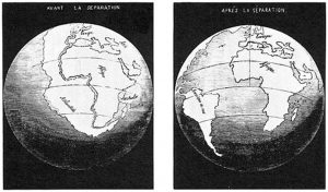
Figure 66. Snider-Pellegrini made these two maps in 1858, showing his interpretation of how the American and African continents once fit together before becoming separated.
Snider-Pellegrini based his theory on the Genesis Flood, the obvious shape and fitting of the continents, and the fact that plant fossils found in both Europe and the United States were identical.[viii]
Modern mapping technologies and the help of bathymetric maps that reveal the shapes and contours of the continental shelf and the ocean floor allow us to clearly see that the continents were once connected and later torn apart. Figure 67 shows what Earth looks like with all the ocean water removed. Without the oceans, the deep shelves on each side of the continents become visible and we can see how the continents fit together like puzzle pieces to shape an Earth that used to be mostly a single land mass.
Interestingly, this perfectly fits the Genesis account: “Then God said, ‘Let the waters under the heavens be gathered together into one place, and let the dry land appear’; and it was so. And God called the dry land Earth, and the gathering together of the waters He called Seas. And God saw that it was good” (Genesis 1:9–10). This is especially obvious when looking at the matching jagged edges of lower South America and Africa (see Figure 67).

Figure 67. Lower South America Matching Africa.[ix]
We can also see how a notch of submerged land off the grand banks of Newfoundland fits nearly perfectly into a slot north of Spain (see Figure 68).
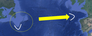
Figure 68. Submerged land off the Grand Banks of Newfoundland fitting into a Slot North of Spain (Google Earth).
From a Biblical standpoint, the continents fit together so well because of the catastrophic linear rifting that occurred when the fountains of the great deep were “cleaved” and pulled apart only a few thousand years ago.
Evidence 2: The Oceanic Ridge System
The oceanic ridge system covers more than 40,000 miles and circles the Earth 1.6 times over.
Figure 69. Oceanic Ridge System.
The Mid-Atlantic Ridge (MAR) represents one of the largest rifts left behind by the global seafloor spreading process. It looks like a giant baseball seam running around the face of the Earth.

Figure 70. Mid-Atlantic Ridge (MAR).[x]
The MAR is part of the longest mountain range in the world and includes perpendicular faults along its entire length, known as transform faults, showing the formation of new seafloor involved a pulling apart of the ocean basin. The sharpness of the faults and the abrupt edges indicate that little time has expired since their formation. The raised and sloped features on each side of the rift also testify to the hot and buoyant rock that still lies beneath it. From a Biblical standpoint, the formation of the Atlantic basin occurred quickly during the Flood and then slowed down greatly to about an inch per year, as GPS measurements today indicate.
Evidence 3: Ring of Fire
The Ring of Fire is a 25,000-mile horseshoe-shaped string of oceanic trenches in the Pacific Ocean basin where about 90% of the world’s earthquakes and a large fraction of the world’s volcanoes occur.[xi] It is also where most of the plate subduction is taking place today. From a Biblical perspective, this long belt of volcanoes and earthquakes marks the location where vast amounts of ocean plate was rapidly subducted into the Earth’s interior during the Flood. Today, by comparison, the speed of subduction is extremely slow, and the resulting earthquakes and tsunamis are dramatically less frequent.
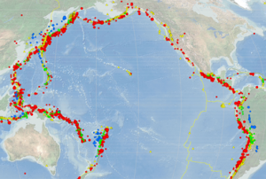
Figure 71. USGS 1900-2013 Earthquakes in the Ring of Fire.[xii]
How is CPT different from the secular understanding of plate tectonics?
CPT is basically the expression at the Earth’s surface of a recent, massive, and rapid overturn of rock inside the region inside the Earth known as the mantle, which is the 1,800-mile thick layer of rock between the Earth’s core and its crust. Regions of cooler rock in the upper part of the mantle have a natural tendency to sink downward toward the bottom, and regions of warmer rock at the bottom have a natural tendency to rise upward toward the surface. When conditions are right, this natural tendency for rising and sinking can “run away,” such that both rising and sinking become faster and faster—up to a billion times faster. The force responsible for driving this behavior is simply gravity. From a Biblical perspective, the runaway episode responsible for CPT occurred during the Flood described in Genesis 6–8.
The possibility that runaway behavior might occur in the mantle was discovered decades ago in laboratory studies[xiii] that explored how mantle minerals deform at mantle temperature and stress conditions. These basic experiments revealed that mantle minerals weaken by factors of more than a billion for stress levels that can readily arise inside the Earth. Computer experiments[xiv] later confirmed that episodes of runaway overturn in the mantle are inevitable under the right conditions because of this inherent weakening behavior demonstrated in these laboratory experiments.
What might be the consequences at the Earth’s surface of a runaway overturn event in the mantle? One notable consequence is that the tectonic plates at the Earth’s surface get caught up in the rapid flow of rock within the mantle beneath. In particular, the ocean plates diving into the mantle at the deep-ocean trenches during the overturn did so at a spectacularly accelerated pace compared to today’s rates. Likewise, in zones known today as spreading ridges (such as the Mid-Atlantic Ridge) where tectonic plates are moving apart from one another, the speed of separation during the overturn was dramatically higher.
Just how much faster would the plate motions during such an overturn event be compared with what is occurring today? This can be estimated based on the time frame provided in the Bible’s account of the Flood and on the amount of plate motion associated with the part of the rock record that contains fossils of the plants and animals buried in the Flood. From these numbers one obtains a plate speed on the order of five miles-per-hour. A typical plate speed today, as measured by GPS, is on the order of a couple inches per year. The ratio of these two speeds is about one billion to one.
What are other noteworthy consequences of such rapid plate motions? One is that water on the ocean bottom in the zones where plates were moving apart so rapidly was in direct contact with the molten rock which was rising from below to fill the gap between the plates. This molten rock at about 1300º C converted the ocean water to steam at extremely high pressure. This steam organized to form in a linear chain of intense supersonic jets along the entire midocean ridge system. As these jets pierced the layer of ocean water above where they were formed, they entrained massive amounts of liquid seawater, which was lofted high above the Earth. This liquid water then fell back to the surface as rain. Hence, a direct consequence of rapid plate motions was persisting rain over much if not most of the Earth.
A second prominent consequence of rapid plate motion was a rising sea level that flooded the land surface with ocean water. The rising sea level resulted from a decrease in the volume of the ocean basins. Behind that decrease was the loss of original cold ocean plate as it plunged into the mantle at an ocean trench and its replacement with new and much warmer ocean plate produced by seafloor spreading at a mid-ocean ridge. The new plate was on average 500–1000º C warmer than the cold plate it replaced. Because warm rock of a given mass has more volume than cold rock of the same mass, the ocean floor above new ocean floor was 0.6–1.2 miles higher than was the old ocean floor. As more and more new ocean floor was generated at mid-ocean ridges, while more and more of the original ocean floor was removed by recycling into the mantle, the global sea level relative to the land surface rose by thousands of feet. Hence, a notable result of rapid plate motion was a rising sea level and a dramatic flooding of the continents by ocean water.
A third major consequence of the rapid plate motion is the generation of a huge number of giant tsunamis. In today’s world, at an ocean trench where an oceanic plate is steadily slipping into the mantle, the adjacent overriding plate generally is locked against it and is bent downward as the other plate slides into the mantle (see Figure 72). As this motion proceeds, the overriding plate is deformed more and more in a spring-like manner until a stress limit is exceeded. At this point the two plates unlock, significant slip between the plates occurs, and the overriding plate returns to its original shape. Such an unlocking and slip event usually produces an earthquake. If the slip event is large enough it also can launch a tsunami. During the Flood, when plate speeds were a billion times faster than today, it is almost certain that this same locking and unlocking phenomenon also prevailed. The higher plate speeds and the huge amount of seafloor recycled into the mantle would have generated vast numbers of huge tsunamis. Conservative estimates are in the range of 50,000–100,000 or more tsunamis, with wave heights in the range of hundreds of feet or higher.

Figure 72. Making a Tsunami.[xv]
Numerical experiments undertaken by Dr. Baumgardner to model the erosion and sediment deposition aspects of this sort of tsunami activity show that it is readily capable of producing the observed continent sediment record. This work is described in a recent paper titled, “Understanding how the Flood sediment record was formed: The role of large tsunamis.”[xvi] Figure 73 shows a plot from this simulation that includes the plate motions.[xvii] Hence, a third major result of rapid plate motion is the formation of the observed layer-cake pattern of fossil-bearing sediments across the continents.
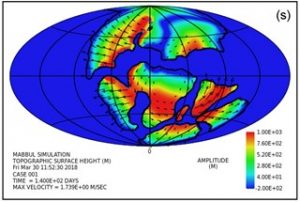
Figure 73. Plot from Dr. John Baumgardner’s CPT Tsunami Simulation.[xviii]
Dr. Baumgardner’s simulation allows us in a limited way to rewind time to gain some insight into what happened during the year-long Genesis Flood. Below we’ll review some of the major physical evidences that support CPT.
Physical evidences that support the reality of CPT
Evidence 1: Catastrophic Subduction
The oceanic plates that rapidly subducted under the continents during the Flood are still visible! Seismic images of the mantle reveal a ring of unexpectedly cold rock at the bottom of the mantle, beneath the subduction zones that surround the Pacific Ocean. This structure is obtained using a technique known as seismic tomography that folds together data from 10,000 or more seismograms at once (see Figure 74).  Figure 74. Cold Plates (Blue) that Subducted under the Continents During the Flood.[xix]
Evidence 2: The Fossil Record
The action of CPT caused the oceanic plates to subduct rapidly under the land masses and generate cycles of tsunamis that brought staggering quantities of sediment onto land that wiped out every living creature in their paths, burying them in the mud layers we still see today. These types of tsunamis still occur, although much less frequently and on a smaller scale. The moving sea floor subducts, snags under the land masses, and then releases, creating mud-filled tsunamis that carry debris and sea life onto land, sorting them in layers.
Giant, high-frequency tsunamis that were occurring during the Flood explain why today we see dinosaur graveyards around the world, including 13 states in the middle of America, containing dead dinosaurs mixed with marine life (see Figure 75). What type of flood could do this? Just how much water would it take to bury millions of land creatures under hundreds of feet of mud and sand in the Morrison Formation (a 13-state, 700,000 square mile area)?

Figure 75. Morrison Formation.[xx]
Just how did so many land creatures get buried together with marine life, with 97% of the dinosaurs found disarticulated,[xxi] and many of the remaining 3% that are found intact discovered in mud and sand layers with their necks arched back, suffocating as they died?[xxii]
A global inundation that covered most of North America is no secret to secular geologists, but they call it something different: the “widespread Late Cretaceous transgression”[xxiii] (essentially technical jargon for “worldwide flood”). Studies have revealed that “a sea level rise of 310 meters is required to flood the Cretaceous layers based on their current elevation.” The challenge for secular geologists, however, is that the maximum thickness of the fossil layers produced by a 310-meter sea level rise is only about 700 meters, but in North America, nearly 50 percent of the Cretaceous layers contain strata thicker than 700 meters.
Sediment transport via highly turbulent tsunami-driven flow described in Baumgardner’s published work logically seems to be required to account for these thick layers. These layers also suggest that the continents had to down warp locally during this global inundation, as Baumgardner’s modeling likewise suggests. This is what CPT predicts and what the Flood would have done. There’s just no way that rising sea levels alone can explain the fossil record in North America—mechanisms much more powerful and catastrophic had to be involved.
Evidence 3: Fossil Correlation[xxiv]
By comparing fossils of small organisms found on the ocean floor with fossils of the same organisms on different continents, it has been possible to determine when the ocean crust formed in terms of the fossil sequence found in the continental sediments. What has been discovered, both from a creationist as well as from a secular understanding, is that much of the continental fossil record was already in place before any of the present-day ocean crust had come into existence. For example, all the trilobite fossils had already been deposited, plus all the older coal deposits (Pennsylvanian System coals) had already been formed before any of the present-day ocean crust had formed.

Figure 76. Reassembling the continents shows a trilobite habitat torn apart by the Flood.[xxv]
The fossil record (e.g., certain trilobite species) that now straddles both sides of the MAR testify to the rapid nature of this catastrophe, with millions of the same kinds of animals that were once living together now found buried in mud and lime layers on either side of the rift.
In the creationist understanding, the presence of fossils is a trustworthy indicator of the action of the Flood, meaning that a large part of the Flood cataclysm had already unfolded and had generated fossil-bearing sediments on the continental surface before any of the present-day ocean floor had appeared. It further implies that all of today’s ocean floor formed since the onset of the Flood, during roughly the latter half of the cataclysm. It also means that all the pre-Flood ocean floor, plus any ocean floor formed during the earlier portion of the Flood, must have been recycled into the Earth’s interior during the cataclysm. These considerations indicate in a compelling way that rapid plate tectonics must have been a major aspect of the year-long Flood catastrophe.
Evidence 4: Buckled/Folded Sedimentary Layers
The Genesis Flood laid down tens of millions of cubic miles of sediment like sand and mud all over the globe. It soon hardened into rock. These layers contain most of the fossil record. Some of these massive layers are bent and even folded, proving they were laid down rapidly and then bent before hardening into rock. Otherwise they would have crumbled instead of bending plastically. These folded and bent geological features are found all over the world and most occurred during the latter stages of the Flood when 80% of the world’s mountains rapidly formed.

Figure 77. Example of Massive Geologic Folding.[xxvi]
Evidence 5: River Fans
If the evolutionary view about the continents were true (that they moved apart slowly over millions of years), the large rivers on the continents that empty into the Atlantic Ocean would have left a connected trail of mud stretching from one side of the Atlantic to the other. But what the evidence actually shows is that most of the seafloor spreading that formed the Atlantic was over before continental runoff and major transport of sediment into the Atlantic basin began. Major rivers like the Congo, Mississippi, and Amazon run off the continents and have mud fans with only thousands of years’ worth of mud deposits—not millions.

Figure 78. Amazon River Fan (Google Earth)
There are flat sand bottoms on each side of the continents showing they were split apart rapidly—they don’t have millions of years’ worth of runoff with considerable mud extending into the ocean. The continental shelves exhibit little erosion and still match nearly perfectly when put back together. Millions of years of erosion would have destroyed much of the sharp continental shelfs. These rivers began shaping and eroding only thousands of years ago, not millions.
Evidence 6: Sloss Megasequences
Dr. Tim Clarey has conducted extensive research on the Genesis Flood using over 2,000 stratigraphic columns (bore holes) from across North and South America, Africa, and Europe.[xxvii] These data confirm the existence of six megasequences (called “Sloss-type megasequences”), large-scale sequences of sedimentary deposits that reveal six different stages of global depositions that occurred during the Flood.
The three earliest megasequences (Sauk, Tippecanoe, and Kaskaskia) contained mostly marine fossils, indicating that only shallow marine areas were swamped and buried by CPT-caused tsunamis. The 4th megasequence (Absaroka) shows a dramatic rise in ocean level and overall global coverage and volume. This sequence also includes the first major plant (coal) and terrestrial animal fossils. The 5th megasequence (Zuni) was mostly responsible for the demise of the dinosaurs and appears to be the highest water point of the Flood (its zenith) because it shows the highest levels of sediment coverage and volume compared to earlier megasequences. The final megasequence (Tejas) contains fossils from the highest upland areas of the pre-Flood world. Together, these megasequences explain why over 75% of Earth is covered by an average of about one mile of sedimentary deposits.

Figure 79. World Sediment Map (showing 75% of Earth’s surface is covered by an average of about one mile of sedimentary deposits).
Evidence 7: Massive Coal Deposits
One of the highest and most severe stages of the Flood occurred during the 4th Sloss megasequence, the Absaroka. Land creatures and plants start showing up in the fossil record laid down by this megasequence. This is also the time when the world’s ocean floor began to be created anew. In other words, the oldest ocean crust today only goes back to the time of the deposition of the Absaroka megasequence.
Notice the top bars in the first seven labeled rows in Figure 80. This shows the global animal fossil occurrences from the Paleobiology Database.[xxviii] The lower, blue bars in each row represent aquatic animals and the top, red bars represent land animals. The megasequences are shown on the left. Note that few land animals appear until the end of the Kaskaskia, then land animals begin increasingly showing up in the fossil record as the Flood progressed.

Figure 80. Sloss Megasequences and Fossil Deposits.[xxix]
Entire ecosystems were buried during this megasequence in enormous deposits that later turned into coal, such as the extensive Appalachian coal beds. Even more coal was formed in the later Zuni and Tejas Megasequences as the waters of the Flood rose yet higher. The U.S. has over seven trillion tons of coal reserves. Where did it all come from? While we know that coal is formed by dead plant material being sandwiched between sediment layers, we only have enough vegetation on the Earth’s surface today to produce just a fraction of the existing coal reserves.[xxx] This shows that the pre-Flood world was mostly covered by lush vegetation. The rising Flood waters and tsunamis that were necessary to sweep over the land and bury vast amounts of vegetation that turned into coal are best explained by a catastrophe of worldwide proportions.

Figure 81. United States Coal Beds.[xxxi]
In the later run-off stages of the Flood (called the Tejas sequence), plants swept off the pre-Flood lands formed massive coal beds such as in the Powder River Basin of Wyoming and Montana. The Powder River Basin layers are the largest coal deposits in North America, currently supplying over 40% of the coal in the U.S. Some of these stacked coal beds are up to 200 feet thick and cover areas that are 60 miles long by 60 miles wide. The sheer volume of plant material required to form such a massive layer of coal testifies to catastrophic circumstances.
[i] “Plate Tectonics: Shaping the Continents.” California Academy of Sciences. www.calacademy.org/explore-science/plate-tectonics-shaping-the-continents. Accessed September 22, 2020.
[ii] Image credit: Dr. John Baumgardner.
[iii] Answers in Depth, Vol. 5 (2010). www.answersingenesis.org/doc/articles/aid/v5/catastrophic_plate_tectonics.pdf (November 5, 2018).
[iv] See: “Noah’s Flood and Catastrophic Plate Tectonics (from Pangea to Today).” Posted July 20, 2018. Genesis Apologetics. https://youtu.be/zd5-dHxOQhg. Accessed September 22, 2020.
[v] Austin, Steve. “Continental Sprint: A Global Flood Model for Earth History – Dr. Steve Austin (Conf Lecture).” Posted February 20, 2019.
Is Genesis History? https://youtu.be/0RLlbUBpzr0. Accessed September 22, 2020.
[vi] Burr, Chandler. “The Geophysics of God: A scientist embraces plate tectonics—and Noah’s flood.” U.S. News & World Report. Archived from the original on August 10, 2007 (Original published June 8, 1997): pp. 55–8.
[vii] Thanks to Dr. John Baumgardner for contributing this section (personal communication, May 21, 2018).
[viii] Plate Tectonics Theory, National Park Service: for Teachers Scalera, Giancarlo. “Roberto Mantovani (1854–1933) and his ideas on the expanding Earth, as revealed by his correspondence and manuscripts.” Annals of Geophysics 52 (6) (December 2, 2009): 617.
[ix] Earth bathymetry by AlteredQualia (Data from NASA Blue Marble). AlteredQualia.com. https://alteredqualia.com/xg/examples/earth_bathymetry.html. Accessed September 22, 2020.
[x] Atlantic Ocean Floor. National Geographic Magazine (June, 1968).
[xi] “Ring of Fire.” USGS. July 24, 2012. Retrieved June 13, 2013; “Where do earthquakes occur?” USGS. May 13, 2013. Archived from the original on August 5, 2014. Retrieved June 13, 2013.
[xii] Image credit: Wikipedia.
[xiii] Kirby, S. H. (1983) “Rheology of the lithosphere,” Reviews of Geophysics and Space Physics 25, 1219–1244.
[xiv] Baumgardner, J. R. (2003) “Catastrophic plate tectonics: the physics behind the Genesis Flood,” in Proceedings of the Fifth International Conference on Creationism, R. L. Ivey, Jr., Editor, Creation Science Fellowship, Pittsburgh, PA, 113–126.
[xv] Baumgardner, 2018.
[xvi] Baumgardner, J. R. (2018). Understanding how the Flood sediment record was formed: The role of large tsunamis. In Proceedings of the Eighth International Conference on Creationism, ed. J.H. Whitmore, 287–305. Pittsburgh, Pennsylvania: Creation Science Fellowship.
[xvii] Ibid.
[xviii] Ibid.
[xix] Baumgardner, J. R. (2018). “The Importance of the Genesis Flood to a Correct Understanding of the Earth’s Past” (PowerPoint Presentation).
[xx] Image credit: Morris, John D. The Global Flood: Unlocking Earth’s Geologic History. Dallas, TX: Institute for Creation Research. 2012.
[xxi] Werner, Carl. “Evolution the Grand Experiment,” The Grand Experiment: www.thegrandexperiment.com/index.html (January 1, 2014).
[xxii] There is disagreement in the paleontology field as to whether the “dinosaur death pose” is due to choking while dying from drowning, or due to strong water currents arching the neck back after death. See: Reisdorf, Achim G. & Wuttke, Michael. “Re-evaluating Moodie’s Opisthotonic-Posture Hypothesis in Fossil Vertebrates Part I: Reptiles—the taphonomy of the bipedal dinosaurs Compsognathus longipes and Juravenator starki from the Solnhofen Archipelago (Jurassic, Germany),” Palaeobiodiversity and Palaeoenvironments 92 (2012): 119–168. Their findings stated, “From what has been presented above, it can be concluded that the formation of the ‘opisthotonic posture’ in subaquatically deposited carcasses of long-necked and long-tailed reptiles is the result of a postmortem process…this posture must be seen as a normal phenomenon that occurs during subaquatic gradual embedding of these sorts of carcasses.”
[xxiii] Liu, L., Spasojevi, S. & Gurnis, M. (2008), Reconstructing Farallon Plate Subduction Beneath North America back to the Late Cretaceous, Science,
322, 934–938; Spasojevi, S., Liu, L. & Gurnis, M. “Adjoint Convection Models of North America Incorporating Tomographic, Plate motion and Stratigraphic Constraints.” Geochem., Geophy., Geosys 10 (2009) Q05W02; Bond, Gerard. “Evidence for continental subsidence in North America during the Late Cretaceous global submergence.” Geology 4 (9) (September 1, 1976): 557–560; Cross, Timothy A. & Pilger, Rex H. Jr. “Tectonic controls of late Cretaceous sedimentation, western interior, USA.” Nature, Volume 274, 653–657 (1978).
[xxiv] Thanks to Dr. John Baumgardner for contributing this section (personal communication, May 21, 2018).
[xxv] Data from the Paleobiology Database: https://paleobiodb.org/navigator/. Accessed January 26, 2017.
[xxvi] Image credit: Vail, Tom. “Bent Rocks.” Posted December 8, 2015. Canyon Ministries. www.canyonministries.org/bent-rock-layers/. Accessed September 22, 2020.
[xxvii] Clarey, T.L. & Werner, D.J. “Use of sedimentary megasequences to re-create pre-Flood geography.” In Proceedings of the Eighth International Conference on Creationism, ed. J.H. Whitmore, (2018): pp. 351–372. Pittsburgh, Pennsylvania: Creation Science Fellowship. Note: the literature on this topic reports 1,500 bore holes, but this has since increased to 2,000.
[xxviii] Courtesy of Dr. Nathaniel Jeanson.
[xxix] Image credit: Clarey, T. & D. J. Werner (2018).
[xxx] Snelling, Andrew A., “How Did We Get All This Coal?” Posted April 1, 2013. Answers in Genesis. https://answersingenesis.org/biology/plants/how-did-we-get-all-this-coal/. Accessed September 22, 2020.
[xxxi] Map courtesy of Lignite Energy Counsel.
